It was 11 years ago today (also a Sunday) that the Minneapolis tornado devastated north Minneapolis especially but left a trail of damage in St. Louis Park and Columbia heights as well. I was on the air for 3 or 4 hours straight, all by myself at my previous employer broadcasting the latest information.

It was a crazy day. It was a day where we knew the atmosphere could produce some bad weather. I went in early that day to prepare my forecast and graphics ahead of time, knowing that I might be covering severe weather. Still, back in those days we had a 'red phone.' Those phones were at the National Weather Service, Emergency Management offices, and most major media outlets (TV, radio stations). When the red phone rang, you knew major 'stuff' was going down. The phone rang shortly after I arrived at work... a national weather service employee: "TORNADO ON THE GROUND at 394 & highway 100!" I remember right away thinking "SHIT!" (forgive my French).

That tornado ended up being on the ground for 13.6 miles with a width of nearly 1/2 mile. It was rated an EF-1 (100 mph winds). It bobbed up and down initially cutting the tops of trees off near 394/100, skipping through on/off through Theo Wirth park.
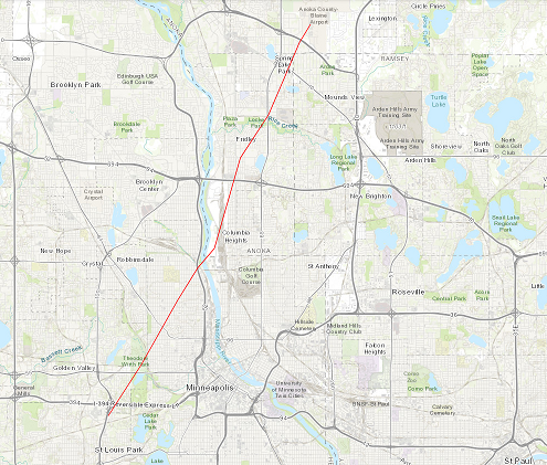
This was just 2 blocks from my house at the time. I took these photos:


One of the few advantages of storms like this going through an urban area, is that they're close to a radar site. This gives meteorologists and researchers tons of data to better understand severe storms and learn from them. Here's what the storm looked like on radar at various points:

*At 2:09 PM (5/11/11) is close to the initial touch down just south of 394 near 100. The tornado was weaker at this point.

* 5 minutes later at 2:14 PM it is moving through the area I posted pictures from (near the intersection of Wirth Parkway and Glenwood Ave.- I lived off of Glenwood and 2nd on Washburn Ave N)... note on the right the brighter colors: this means higher wind speeds; the tornado was intensifying as it was getting ready to hit North Minneapolis.

*At 2:19 PM the tornado is exiting Minneapolis and heading northeast into Columbia Heights. It's starting to weaken somewhat (the brighter colors are smaller on the right).
The tornado on radar exhibited a classic 'hook echo.' The images on the left show rain/hail intensity. The hook area (I've circled in black) shows rain bands wrapping around the tornado counter clockwise looking like a hook, or a backwards letter 'J.'
The right images show storm relative velocity. We use Doppler (much like a state patrol officer does to clock your speed) to deter the direction & speed precipitation is moving. Red/yellow indicates precipitation and debris moving away from the radar, and green/blue indicates it moving toward the radar site. The radar site is to the southwest in Chanhassen (NWS office). When the two colors come together this indicates rotation: we call this a 'couplet.' You'll hear during severe weather coverage that we look for this on radar. When a tornado warning is issued it's often because we see rotation on radar. It doesn't mean it's reaching the ground necessarily but could because the storm is already rotating.
One person lost their life when a tree fell on the car they were in and 48 other people were injured. Considering the path this tornado took it is truly miraculous more people weren't killed or injured.
コメント